Las Vegas Strip Map

Which casinos connect inside, where to cross the Boulevard, and the free trams.

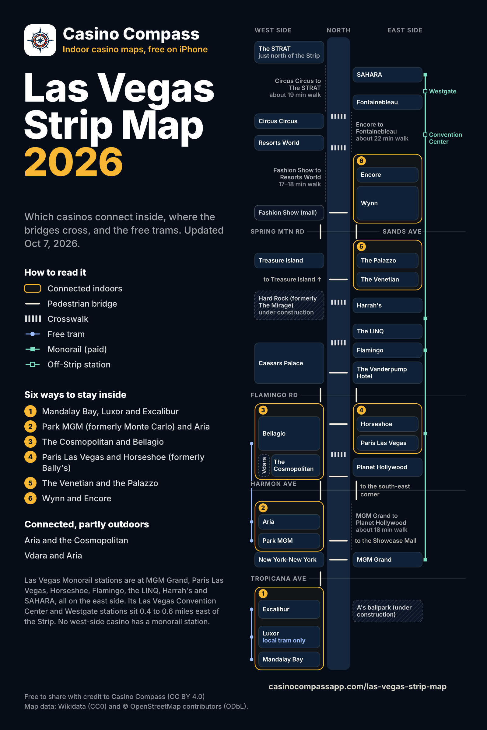
The map

Tap a casino for its walkways, bridges and stations

Map key

  • Connected indoors
  • Pedestrian bridge
  • Crosswalk
  • Free tram
  • Monorail (paid)
  • Off-Strip station

A schematic map of the Las Vegas Strip: the casinos in order on the west and east sides of Las Vegas Boulevard, the indoor islands outlined, the pedestrian bridges and the crosswalks between casinos, the free trams and the monorail. The list below holds every place's walkways, bridges and stations, and the crosswalks between casinos.

The printable one-page PDF: www.casinocompassapp.com/downloads/las-vegas-strip-map-printable.pdf

See every place as a listSave the map imagePrintable PDF (103 KB)

Pick a walk

Tap a casino, bridge or tram stop on the map, and its walkways, bridges and stations open here.

Excalibur to Mandalay Bay

Stays indoors

10–14 min

casino floor to casino floor

You can walk from Excalibur to Mandalay Bay without going outside: through an enclosed walkway to Luxor, then through the Shoppes at Mandalay Place.

  1. Start on the Excalibur casino floor.
  2. Go through an enclosed walkway to Luxor.
  3. Walk through Luxor.
  4. Go through the Shoppes at Mandalay Place to Mandalay Bay.
Mandalay Bay to Luxor guide (one part of this walk) →

Bellagio to Caesars Palace

Outdoors, by bridge

13–14 min

property to property

Bellagio and Caesars Palace sit on opposite corners of Flamingo Road, and you cross on the pedestrian bridge between them.

  1. From Bellagio, cross the bridge over Flamingo Rd between Bellagio and Caesars Palace.
  2. Walk to Caesars Palace.

Until November 9, the sidewalk in front of the Bellagio fountains is closed for Grand Prix construction.

Bellagio to Caesars Palace guide →

Aria to the Cosmopolitan

Connected, partly outdoors

10 min

property to property

You can walk from Aria to the Cosmopolitan through the Shops at Crystals, but part of the walk is outside, on an open-air bridge across Harmon Avenue.

  1. Start on the Aria casino floor.
  2. Go out of the Shops at Crystals and over the open-air bridge across Harmon Ave to the Cosmopolitan.

MGM Grand to SAHARA (formerly SLS Las Vegas)

Too far to walk

15 min on the Las Vegas Monorail

ride time, station to station

The ride time leaves out the walks to the stations at the back of both casinos.

MGM Grand to SAHARA is too far to walk comfortably; the Las Vegas Monorail runs between stations behind both casinos.

  1. Walk to the MGM Grand station of the Las Vegas Monorail.
  2. Ride to SAHARA Las Vegas.
  3. Walk to SAHARA.

Paris Las Vegas to Horseshoe (formerly Bally's)

Stays indoors

4–5 min

casino floor to casino floor

Paris and Horseshoe connect indoors: a walkway runs between the two casino floors.

  1. Start on the Paris Las Vegas casino floor.
  2. Go through the walkway between the two casino floors to Horseshoe.
Horseshoe guide →

The Venetian to the Palazzo

Stays indoors

5 min

casino floor to casino floor

The Venetian and the Palazzo are one connected resort, so you walk between them indoors, through the casino floor and the Grand Canal Shoppes.

  1. Start on the Venetian casino floor.
  2. Go through the shared casino floor and the Grand Canal Shoppes to the Palazzo.
Venetian & Palazzo guide →

The Venetian to Wynn

Outdoors, by bridge

17 min combined

  • the Venetian to the Palazzo: 5 min, casino floor to casino floor
  • the Palazzo to Wynn: 12 min, property to property

From the Venetian, walk indoors to the Palazzo, then cross Sands Avenue on the pedestrian bridge to Wynn; there is no street crosswalk there.

  1. Start on the Venetian casino floor.
  2. Go through the shared casino floor and the Grand Canal Shoppes to the Palazzo.
  3. From the Palazzo, cross the bridge over Sands Ave between the Palazzo and Wynn.
  4. Walk to Wynn.
The Venetian to Wynn guide →

The Venetian to Bellagio

Outdoors, by bridge

23–25 min

property to property

From the Venetian, walk south on its side of the Strip to Flamingo Road, then take the two bridges across to Caesars Palace and on to the Bellagio.

  1. From the Venetian, cross the bridge over Las Vegas Blvd at Flamingo Rd, between Caesars Palace and the Vanderpump Hotel.
  2. Then cross the bridge over Flamingo Rd between Bellagio and Caesars Palace.
  3. Walk to Bellagio.

Or cross at the street crosswalk at Harrah's and cut through Caesars Palace from the Forum Shops.

The Venetian to Bellagio guide →

Caesars Palace to the Venetian

Outdoors, by bridge

15 min

property to property

From Caesars Palace, cross Las Vegas Boulevard on the bridge at Flamingo Road, then walk north on the east side to the Venetian.

  1. From Caesars Palace, cross the bridge over Las Vegas Blvd at Flamingo Rd, between Caesars Palace and the Vanderpump Hotel.
  2. Walk to the Venetian.

Leaving by the Forum Shops? The street crosswalk at Harrah's is closer.

Caesars Palace to the Venetian guide →

Mandalay Bay to Allegiant Stadium

Outdoors, by bridge

18 min

street to entrance, from the Strip at Mandalay Bay Road to the stadium

Allegiant Stadium is across I-15 from Mandalay Bay. From the Strip, walk west on Mandalay Bay Road, between Mandalay Bay and Luxor; it becomes Hacienda Avenue, which crosses I-15 on a bridge to the stadium.

  1. From Mandalay Bay, cross the Hacienda Avenue bridge over I-15.
  2. Walk to Allegiant Stadium.

On game days and some event days, the bridge closes to cars and opens to walkers only.

Mandalay Bay to Allegiant Stadium guide →
Find the right exit inside with the free Casino Compass app

Six ways to stay inside

Each group connects without going outside.

  1. Mandalay Bay, Luxor and Excalibur

    10–14 min end to end (casino floor to casino floor)

  2. Park MGM (formerly Monte Carlo) and Aria

    4–5 min (casino floor to casino floor)

  3. The Cosmopolitan and Bellagio

    9–10 min (casino floor to casino floor)

  4. Paris Las Vegas and Horseshoe (formerly Bally's)

    4–5 min (casino floor to casino floor)

  5. The Venetian and the Palazzo

    5 min (casino floor to casino floor)

  6. Wynn and Encore

    5–6 min (casino floor to casino floor)

Connected, partly outdoors

You can walk between these, but part of the walk is outside.

  • Aria and the Cosmopolitan

    Out of the Shops at Crystals and over the open-air bridge across Harmon Ave.

  • Vdara and Aria

    An outdoor walk between the two entrances.

The free Casino Compass app maps the inside of 20+ Strip casinos, so you can find the exit you need.

Get the free app

Free trams and the monorail

Aria Express

Cost
Free
Stops
Bellagio (Bellagio and Vdara) · Crystals / CityCenter (Aria) · Park MGM
Hours
Hours vary; check before you go
How often
Every 7–10 min
Ride
About 6 min end to end

Mandalay Bay – Luxor – Excalibur Tram

Cost
Free
Stops
Excalibur North · Excalibur · Luxor · Mandalay Bay
Hours
Hours vary; check before you go
How often
Every 3–7 min
Ride
About 7 min end to end
Tip
Only the local tram stops at Luxor; the express runs straight between Excalibur and Mandalay Bay. From Excalibur to Luxor, the indoor walkway is the sure way.

Las Vegas Monorail

Every station is on the east side; no west-side casino has one.

Cost
Paid (fares on the operator's site)
Stops
MGM Grand · Horseshoe / Paris (Horseshoe and Paris Las Vegas) · Flamingo / Caesars Palace (Flamingo) · Harrah's / The LINQ (Harrah's and the LINQ) · Las Vegas Convention Center · Westgate · SAHARA Las Vegas
Hours
Mon 7am–midnight; Tue–Thu 7am–2am; Fri–Sun 7am–3am
How often
Every 4–8 min
Ride
About 15 min end to end
Tip
Check the operator's site for the day's hours before you go.
The map as a list: casinos, bridges and stations the text version of the map, south to north

Casinos, hotels and venues in Strip order

Walkways, bridges and stations for each place, south to north. Tap “Back to the map” to return.

South Strip

Mandalay Bay

Walkways
Indoors to Luxor, through the Shoppes at Mandalay Place
Stations
Mandalay Bay – Luxor – Excalibur Tram: Mandalay Bay station
Back to the map

Luxor

Walkways
Indoors to Excalibur, through an enclosed walkwayIndoors to Mandalay Bay, through the Shoppes at Mandalay Place
Stations
Mandalay Bay – Luxor – Excalibur Tram: Luxor station
Back to the map

Excalibur

Walkways
Indoors to Luxor, through an enclosed walkway
Bridges
The bridge over Tropicana Ave between Excalibur and New York-New York
Stations
Mandalay Bay – Luxor – Excalibur Tram: Excalibur North stationMandalay Bay – Luxor – Excalibur Tram: Excalibur station
Back to the map

Center Strip

Park MGM

Formerly Monte Carlo

Walkways
Indoors to Aria, through the shared Aria Express station level
Bridges
The bridge over Las Vegas Blvd between Park MGM and the Showcase Mall
Stations
Aria Express: Park MGM station
Back to the map

Aria

Walkways
Indoors to Park MGM, through the shared Aria Express station levelTo the Cosmopolitan, partly outdoors: out of the Shops at Crystals and over the open-air bridge across Harmon AveTo Vdara, partly outdoors: an outdoor walk between the two entrances
Bridges
The open-air bridge over Harmon Ave between the Shops at Crystals and the Cosmopolitan
Stations
Aria Express: Crystals / CityCenter station
Back to the map

Vdara

A hotel with no casino, next to Aria

Walkways
On the indoor walkway between the Cosmopolitan and BellagioTo Aria, partly outdoors: an outdoor walk between the two entrances
Stations
Aria Express: Bellagio station
Back to the map

The Cosmopolitan

Walkways
Indoors to Bellagio, through the Vdara walkway, from Level 2 of the Cosmopolitan's Chelsea TowerTo Aria, partly outdoors: out of the Shops at Crystals and over the open-air bridge across Harmon Ave
Bridges
The bridge over Las Vegas Blvd at Harmon Ave, between the Cosmopolitan and Planet HollywoodThe open-air bridge over Harmon Ave between the Shops at Crystals and the Cosmopolitan
Crosswalk
Across Las Vegas Blvd from Bellagio Dr to Planet Hollywood
Back to the map

Planet Hollywood

Formerly Aladdin

Bridges
The bridge over Las Vegas Blvd at Harmon Ave, between the Cosmopolitan and Planet Hollywood
Crosswalk
Across Las Vegas Blvd from Bellagio Dr to Planet Hollywood
Stations
Las Vegas Monorail: nearest station is Horseshoe / Paris
Back to the map

Bellagio

Walkways
Indoors to the Cosmopolitan, through the Vdara walkway, from Level 2 of the Cosmopolitan's Chelsea Tower
Bridges
The bridge over Las Vegas Blvd at Flamingo Rd, between Bellagio and HorseshoeThe bridge over Flamingo Rd between Bellagio and Caesars Palace
Crosswalk
Across Las Vegas Blvd from Bellagio Dr to Planet Hollywood
Stations
Aria Express: Bellagio station
Back to the map

Paris Las Vegas

Walkways
Indoors to Horseshoe, through the walkway between the two casino floors
Stations
Las Vegas Monorail: Horseshoe / Paris station
Back to the map

Horseshoe

Formerly Bally's

Walkways
Indoors to Paris Las Vegas, through the walkway between the two casino floors
Bridges
The bridge over Las Vegas Blvd at Flamingo Rd, between Bellagio and HorseshoeThe bridge over Flamingo Rd between Horseshoe and the Vanderpump Hotel
Stations
Las Vegas Monorail: Horseshoe / Paris station
Back to the map

Flamingo

Crosswalk
Across Las Vegas Blvd from Caesars Palace Dr, between the Flamingo and the LINQ
Stations
Las Vegas Monorail: Flamingo / Caesars Palace station
Back to the map

Caesars Palace

Bridges
The bridge over Las Vegas Blvd at Flamingo Rd, between Caesars Palace and the Vanderpump HotelThe bridge over Flamingo Rd between Bellagio and Caesars Palace
Crosswalks
Across Las Vegas Blvd from Caesars Palace Dr, between the Flamingo and the LINQAcross Las Vegas Blvd from the Forum Shops exit to Harrah's
Stations
Las Vegas Monorail: Flamingo / Caesars Palace station is across the Boulevard
Back to the map

The LINQ

Formerly The Quad and Imperial Palace

Crosswalk
Across Las Vegas Blvd from Caesars Palace Dr, between the Flamingo and the LINQ
Stations
Las Vegas Monorail: Harrah's / The LINQ station
Back to the map

Harrah's

Crosswalk
Across Las Vegas Blvd from the Forum Shops exit to Harrah's
Stations
Las Vegas Monorail: Harrah's / The LINQ station
Back to the map

Hard Rock

Formerly The Mirage

Under construction

Back to the map

The Venetian

Walkways
Indoors to the Palazzo, through the shared casino floor and the Grand Canal Shoppes
Bridges
The bridge over Las Vegas Blvd between Treasure Island and the Venetian
Back to the map

The Palazzo

Walkways
Indoors to the Venetian, through the shared casino floor and the Grand Canal Shoppes
Bridges
The bridge over Sands Ave between the Palazzo and Wynn
Back to the map

North Strip

Encore

Walkways
Indoors to Wynn, through the Esplanade shops
Crosswalk
Across Las Vegas Blvd from Genting Blvd to Encore Resort Blvd
Back to the map

Resorts World

Crosswalk
Across Las Vegas Blvd from Genting Blvd to Encore Resort Blvd
Back to the map

Circus Circus

Crosswalk
Across Las Vegas Blvd from Circus Circus Dr to Elvis Presley Blvd
Back to the map

Fontainebleau

Crosswalk
Across Las Vegas Blvd from Circus Circus Dr to Elvis Presley Blvd
Back to the map

SAHARA

Formerly SLS Las Vegas

Stations
Las Vegas Monorail: SAHARA Las Vegas station
Back to the map

The STRAT

Formerly Stratosphere

Just north of the Strip

Back to the map

Venues and landmarks

A's ballpark (under construction)

Under construction

Back to the map

T-Mobile Arena

Back to the map

High Roller

Back to the map

Las Vegas Convention Center

Stations
Las Vegas Monorail: Las Vegas Convention Center station
Back to the map

Pedestrian bridges, by intersection

Each bridge's landings and whether it is open.

Tropicana Ave

No street-level crosswalks: you cross on the pedestrian bridges.

The bridge over Las Vegas Blvd at Tropicana Ave, between New York-New York and MGM Grand

Landings
New York-New York and MGM Grand
Status
Open
Back to the map

The bridge over Las Vegas Blvd at Tropicana Ave, between Excalibur and the A's ballpark site

Landings
Excalibur and the A's ballpark site
Status
Closed in 2024 for the A's ballpark construction, and Clark County's bridge map still showed it closed in July 2026, so it's left off the map. Between Excalibur and MGM Grand, cross by way of New York-New York.
Back to the map

The bridge over Tropicana Ave between Excalibur and New York-New York

Landings
Excalibur and New York-New York
Status
Open
Back to the map

The bridge over Tropicana Ave between the A's ballpark site and MGM Grand

Landings
the A's ballpark site and MGM Grand
Status
Closed in 2024 for the A's ballpark construction, and Clark County's bridge map still showed it closed in July 2026, so it's left off the map. Between Excalibur and MGM Grand, cross by way of New York-New York.
Back to the map

Mid-block, between Tropicana Ave and Harmon Ave

The bridge over Las Vegas Blvd between Park MGM and the Showcase Mall

Landings
Park MGM and the Showcase Mall
Status
Open
Back to the map

Harmon Ave

The bridge over Las Vegas Blvd at Harmon Ave, between the Cosmopolitan and Planet Hollywood

Landings
the Cosmopolitan and Planet Hollywood
Status
Open
Back to the map

The bridge over Harmon Ave east of the Boulevard, from Harmon Corner

Landings
Harmon Corner and the south-east corner of Harmon Ave
Status
Open
Back to the map

The open-air bridge over Harmon Ave between the Shops at Crystals and the Cosmopolitan

Landings
the Shops at Crystals and the Cosmopolitan
Status
Open
Back to the map

Flamingo Rd

The bridge over Las Vegas Blvd at Flamingo Rd, between Bellagio and Horseshoe

Landings
Bellagio and Horseshoe
Status
Open
Back to the map

The bridge over Las Vegas Blvd at Flamingo Rd, between Caesars Palace and the Vanderpump Hotel

Landings
Caesars Palace and the Vanderpump Hotel
Status
Open
Back to the map

The bridge over Flamingo Rd between Bellagio and Caesars Palace

Landings
Bellagio and Caesars Palace
Status
Open
Back to the map

The bridge over Flamingo Rd between Horseshoe and the Vanderpump Hotel

Landings
Horseshoe and the Vanderpump Hotel
Status
Open
Back to the map

Hacienda Ave, over I-15 (off the Boulevard)

The Hacienda Avenue bridge over I-15

Landings
Frank Sinatra Dr (the west end of Mandalay Bay Road) and Allegiant Stadium
Status
Open
Back to the map

Spring Mountain Rd / Sands Ave

No street-level crosswalk across Sands Ave between the Palazzo and Wynn: you cross on the pedestrian bridge.

The bridge over Las Vegas Blvd between Treasure Island and the Venetian

Landings
Treasure Island and the Venetian
Status
Open
Back to the map

The bridge over Las Vegas Blvd between Fashion Show and Wynn

Landings
Fashion Show and Wynn
Status
Open
Back to the map

The bridge over Spring Mountain Rd between Treasure Island and Fashion Show

Landings
Treasure Island and Fashion Show
Status
Open
Back to the map

The bridge over Sands Ave between the Palazzo and Wynn

Landings
the Palazzo and Wynn
Status
Open
Back to the map

Using this map

The map is free to share under CC BY 4.0 with credit to Casino Compass. Updated Oct 7, 2026.

Credit line

Map: Casino Compass (https://www.casinocompassapp.com/las-vegas-strip-map), CC BY 4.0.

Embed it on your site

<a href="https://www.casinocompassapp.com/las-vegas-strip-map"><img src="https://www.casinocompassapp.com/images/las-vegas-strip-map.png" width="1600" height="2400" alt="Las Vegas Strip map by Casino Compass"></a>
<p>Map: <a href="https://www.casinocompassapp.com/las-vegas-strip-map">Casino Compass</a>, <a href="https://creativecommons.org/licenses/by/4.0/">CC BY 4.0</a>.</p>

Questions about the Strip map

Where can I find a map of the Las Vegas Strip?

Right here: the map above shows the Strip's casinos in order on the west and east sides of Las Vegas Boulevard, the six groups of casinos you can walk between without going outside, the pedestrian bridges, the crosswalks between casinos, the free trams and the monorail.

Which Las Vegas Strip casinos are connected indoors?

Mandalay Bay, Luxor and Excalibur; Park MGM (formerly Monte Carlo) and Aria; the Cosmopolitan and Bellagio; Paris Las Vegas and Horseshoe (formerly Bally's); the Venetian and the Palazzo; Wynn and Encore. Within each group you can walk between the casinos without going outside; the list under the map gives each walkway.

Which casinos connect, but partly outdoors?

Aria and the Cosmopolitan (out of the Shops at Crystals and over the open-air bridge across Harmon Ave); Vdara and Aria (an outdoor walk between the two entrances). You can walk between each pair, but part of the walk is outside.

Where are the pedestrian bridges on the Strip?

At Tropicana Ave, Harmon Ave, Flamingo Rd and Spring Mountain Rd / Sands Ave, plus the bridge over Las Vegas Blvd between Park MGM and the Showcase Mall. The bridge list on this page gives each one's landings and whether it is open.

Are the trams on the Strip free?

Yes. The Aria Express stops at Bellagio, Aria and Park MGM. The Mandalay Bay – Luxor – Excalibur Tram stops at Excalibur, Luxor and Mandalay Bay. Only the local tram stops at Luxor; the express runs straight between Excalibur and Mandalay Bay. From Excalibur to Luxor, the indoor walkway is the sure way. Tram hours vary; check before you go.

Does the Las Vegas Monorail stop on the Strip?

Las Vegas Monorail stations are at MGM Grand, Paris Las Vegas, Horseshoe, Flamingo, the LINQ, Harrah's and SAHARA, all on the east side. Its Las Vegas Convention Center and Westgate stations sit 0.4 to 0.6 miles east of the Strip. No west-side casino has a monorail station.

How long is the Las Vegas Strip, and how long does it take to walk?

Our guide to walking the Las Vegas Strip covers its length and real walking times between the casinos.

Is there a printable Las Vegas Strip map?

Yes. The free printable is a one-page PDF with the map, the indoor islands, the casinos that connect partly outdoors, and the trams, and it reads fine in black and white. It's free to share with credit to Casino Compass.

Find your way inside the casinos

The free Casino Compass app maps the inside of 20+ Strip casinos, so you can find restaurants, restrooms and exits.

Download on the App Store

Map data: Wikidata (CC0) and © OpenStreetMap contributors (ODbL). Sources for each walk and bridge